


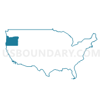
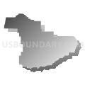
Douglas County PUMA, Oregon
About
Outline

Summary
| Unique Area Identifier | 193823 |
| Name | Douglas County PUMA |
| State | Oregon |
| Area (square miles) | 5,133.77 |
| Land Area (square miles) | 5,036.07 |
| Water Area (square miles) | 97.69 |
| % of Land Area | 98.10 |
| % of Water Area | 1.90 |
| Latitude of the Internal Point | 43.28590350 |
| Longtitude of the Internal Point | -123.15438010 |
Maps

Graphs
Select a template below for downloading or customizing gragh for Douglas County PUMA, Oregon


Neighbors
Neighoring Public Use Microdata Area (by Name) Neighboring Public Use Microdata Area on the Map
- Jackson County (Outside Medford & Central Point Cities)--Ashland City PUMA, OR
- Josephine, Coos & Curry Counties PUMA, OR
- Klamath, Malheur, Lake & Harney Counties PUMA, OR
- Lane County (Outside Eugene & Springfield Cities) PUMA, OR
Top 10 Neighboring County (by Population) Neighboring County on the Map
- Lane County, OR (351,715)
- Jackson County, OR (203,206)
- Douglas County, OR (107,667)
- Josephine County, OR (82,713)
- Klamath County, OR (66,380)
- Coos County, OR (63,043)
- Curry County, OR (22,364)
Top 10 Neighboring County Subdivision (by Population) Neighboring County Subdivision on the Map
- Grants Pass CCD, Josephine County, OR (59,908)
- Roseburg CCD, Douglas County, OR (39,933)
- Cottage Grove CCD, Lane County, OR (18,855)
- Sutherlin CCD, Douglas County, OR (15,877)
- Myrtle Creek-Riddle CCD, Douglas County, OR (14,244)
- Tenmile CCD, Douglas County, OR (9,976)
- Northwest Jackson CCD, Jackson County, OR (7,258)
- Shady Cove CCD, Jackson County, OR (6,921)
- Northwest Josephine CCD, Josephine County, OR (6,694)
- Reedsport CCD, Douglas County, OR (6,027)
Top 10 Neighboring Place (by Population) Neighboring Place on the Map
- Roseburg city, OR (21,181)
- Sutherlin city, OR (7,810)
- Green CDP, OR (7,515)
- Roseburg North CDP, OR (5,912)
- Winston city, OR (5,379)
- Reedsport city, OR (4,154)
- Tri-City CDP, OR (3,931)
- Myrtle Creek city, OR (3,439)
- Canyonville city, OR (1,884)
- Glide CDP, OR (1,795)
Top 10 Neighboring Unified School District (by Population) Neighboring Unified School District on the Map
- Three Rivers School District, OR (47,713)
- Roseburg School District 4, OR (46,695)
- Klamath County School District, OR (42,784)
- Central Point School District 6, OR (29,667)
- Eagle Point School District 9, OR (27,686)
- Coos Bay School District 9, OR (27,065)
- South Lane School District 45J, OR (18,770)
- North Bend School District 13, OR (16,046)
- Siuslaw School District 97J, OR (14,672)
- South Umpqua School District 19, OR (12,372)
Top 10 Neighboring State Legislative District Lower Chamber (by Population) Neighboring State Legislative District Lower Chamber on the Map
- State House District 55, OR (66,629)
- State House District 3, OR (63,226)
- State House District 8, OR (62,550)
- State House District 2, OR (61,776)
- State House District 7, OR (59,574)
- State House District 10, OR (58,977)
- State House District 9, OR (58,778)
- State House District 1, OR (58,501)
Top 10 Neighboring State Legislative District Upper Chamber (by Population) Neighboring State Legislative District Upper Chamber on the Map
- State Senate District 2, OR (126,966)
- State Senate District 28, OR (125,860)
- State Senate District 4, OR (122,124)
- State Senate District 1, OR (120,277)
- State Senate District 5, OR (117,755)
Top 10 Neighboring 111th Congressional District (by Population) Neighboring 111th Congressional District on the Map
Top 10 Neighboring Census Tract (by Population) Neighboring Census Tract on the Map
- Census Tract 1200, Douglas County, OR (7,666)
- Census Tract 1600, Douglas County, OR (7,451)
- Census Tract 800, Douglas County, OR (7,347)
- Census Tract 1500, Douglas County, OR (7,282)
- Census Tract 29, Jackson County, OR (7,258)
- Census Tract 27, Jackson County, OR (6,921)
- Census Tract 500.02, Douglas County, OR (6,865)
- Census Tract 11, Coos County, OR (5,855)
- Census Tract 1, Coos County, OR (5,826)
- Census Tract 900, Douglas County, OR (5,703)
Top 10 Neighboring 5-Digit ZIP Code Tabulation Area (by Population) Neighboring 5-Digit ZIP Code Tabulation Area on the Map
- 97405, OR (44,645)
- 97471, OR (29,100)
- 97470, OR (19,985)
- 97424, OR (17,594)
- 97459, OR (14,096)
- 97503, OR (10,528)
- 97457, OR (10,208)
- 97479, OR (9,505)
- 97496, OR (7,634)
- 97467, OR (5,339)